
We know that rivers are water courses that are constantly in motion as they connect with other larger water courses such as lakes, seas and oceans. These rivers generate very healthy ecosystems rich in biodiversity. in the various parts of a river It is where different ecosystems are generated depending on the environmental conditions and the amount of clean and moving water.
For this reason, we are going to dedicate this article to telling you what the main parts of a river are and what the importance of each of them is.
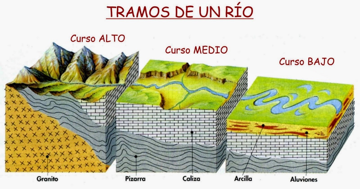
parts of a river

Rivers are shapers of the earth's surface, capable of affecting both vertically and horizontally. Geographically, the three sections of the river are identified by their longitudinal profiles. Or a graphical representation of the channel line from the headwaters to the estuary. Along the route, the flow of the river varies according to the flow, which determines the capacity of erosion, transport and sedimentation of the river.
high course
The upper or upstream course of a river is the part of the river at its headwater (usually in the mountains of a watershed), which then flows down a steep slope and looks like a rapid. Here predominate the high capacity of erosion and transport above the sedimentation.
In this part, erosion at the bottom of the channel creates a V-shaped valley, ravine or canyon where the water is highly oxygenated. The most characteristic forms of this section of the river are: waterfalls, rapids, giant basins, etc.
Middle course
The middle section or middle course of a river is the part of the river where the water flows at a slower rate from upstream. It is characterized by wider channels and streams, gentler slopes, and more transport and sedimentation than erosion.
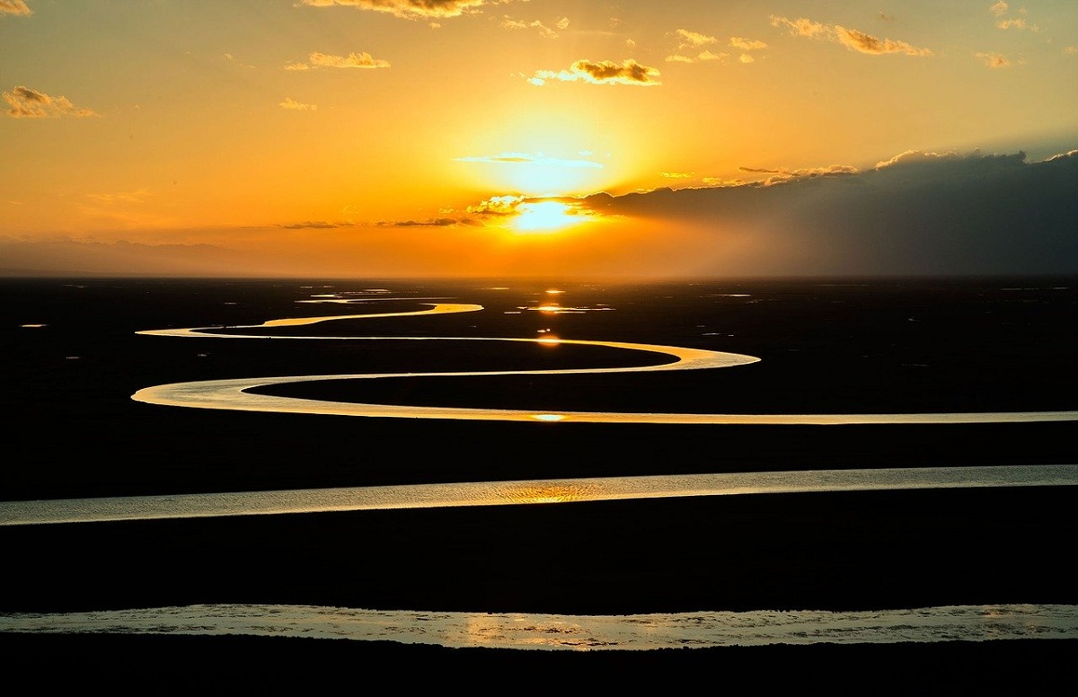
Formation of wide, flat valleys called alluvial plains or flood plains. The channels can be anastomotic and tortuous. With this layout, the erosive action of the water occurs in the open areas of the curve and settles in the interior areas of the curve. As the valley is eroded by meanders, the valley becomes trough-shaped.
low course
In the lower course, the water collected in the middle of the river is discharged downstream or in the river reaches. The slope and the speed of the water are reduced. Loss of erosive capacity, mainly sedimentation and transport of very fine materials.
In this stretch, the flow of the river is small throughout the stretch of the floodplain and is only occupied when floods occur. These vast plains collect transported sediments including nutrients creating a very fertile area known as "Vegas". This water is used for irrigated crops, taking advantage of the fertility of the soil and the water supply. They have some human occupation and pose a danger in the event of floods or rising rivers. In this section it is also common to recharge groundwater in aquifers, sometimes with tributaries.
At the mouth, they can take two forms:
- delta: a large amount of sediment and water flows at low speed. With little activity on the coast, sediments clogged the estuary out to sea.
- Estuary: high-velocity water flow, rapid seaward flow of sediment, and high activity
river characteristics
Rivers can be defined as a significant portion of fresh water located within continental blocks with multiple flows, that is, differences in the amount of water they transport. Secondary streams or rivers that flow into the main river are called tributaries. At the same time, the area through which the main river and its tributaries flow is called the basin, and the river can also fall from the cliff to form a waterfall, commonly known as a waterfall. Rivers are continental water bodies that drain through their channels on the surface of the continent, leaving deposits of mud, sand and small rocks in the process.
Rivers are probably one of the most variable bodies of water known to all. First, this is because the river water is constantly moving and fluctuating. Secondly, because this constant flow means that the same river can see its flow change completely throughout the year, depending on rainfall, drought, etc.
On rare occasions, rivers are not connected to another major waterway, so they get lost in the middle of the land and dry up. However, rivers flow through large or small areas and eventually connect to oceans, seas, or lakes. Therefore, they also allow navigation and the development of basic activities of civilized life.
types of rivers
According to their period of activity, and therefore, the dynamics of the flow and the origin (referring to the amount of water transported), rivers can be classified into:
- Perennial rivers: located in areas with abundant rainfall or good groundwater supply (groundwater).
- Seasonal rivers: Typically alpine, they are typically Mediterranean, where the seasons are very different, with wet and dry periods predominating. That is why they have strong ups and downs in the process.
- transient rivers: Located in areas with a humid or desert climate, they present an irregular flow due to low annual rainfall, so they can remain dry for long periods of time and also suffer violent flooding due to storms and torrential rains.
- allochthonous rivers: They run through arid regions, but their water comes from rainy and humid regions. Example: Nile and Okavango (both African rivers).
- Straight river: The river is a river bed, which is scarce and unstable. They stand out for their low curvature and steep slope, which facilitate the process of dragging and transporting materials.
- Anastomosed rivers: very tortuous, subdivided into several channels, similar to braided rivers, forming semi-permanent and stable fluvial islands. They are usually located in areas with lower slopes and thus dominate the deposition process.
- Braided rivers: They have branches or arms, the route to connect and separate them, draw a braid. They have excessive solids loads (gravel, sand, and clods) and are common in extreme weather conditions.
- meandering rivers: They are stable rivers that curve to form meanders and their banks are dominated by processes of erosion and deposition. They present alluvial plains conducive to flooding processes.
I hope that with this information you can learn more about the parts of a river and its characteristics.